GUESS – GeoneUtrinos: mESSengers of the Earth's interior
A probabilistic 3D crustal model of the Borexino region
This web page provides the 3D crustal model of the 3° × 3° region centered on the Borexino detector (42.45° N, 13.57° E, Laboratori Nazionali del Gran Sasso, L'Aquila, Italy), with a resolution of 4 km × 4 km × 0.1 km voxels. The model is built by Bayesian inversion of multi-source geophysical data, so that every unit carries a quantified uncertainty on volume, mass and density.
Detailed information about this model is published in:
mail_outline Virginia Strati (corresponding author) – strati@fe.infn.it
This work is funded by project GUESS (GeoneUtrinos: mESSengers of the Earth's interior) funded by European Union – NextGenerationEU, Missione 4, Componente 1 (CUP: F53D23001280006).
The GUESS units
The geological formations of the study area are clustered into six GUESS units on the basis of lithology, age and bulk density: Quaternary volcanics, Cenozoic terrigenous sediments, Mesozoic carbonates, Permian-Triassic succession, Upper Crust and Lower Crust.

(a) Geological map of the study area; (b) surface classification into GUESS units, with major thrusts and normal faults. BX marks the Borexino detector.
Input data
The a priori model is constrained by 53 deep exploration wells (ViDEPI), 38 geological and seismic-interpreted cross-sections, including six from the RETRACE-3D model, and 154 receiver-function Moho depth points, complemented by the TINITALY topography and EMODnet bathymetry at 100 m resolution.
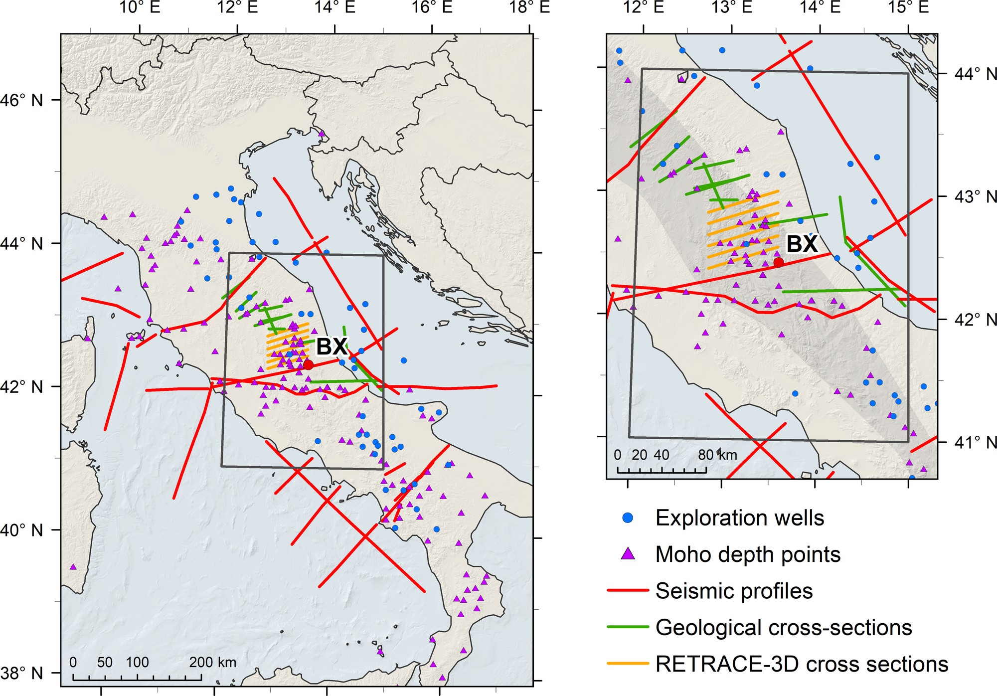
Spatial distribution of the inputs: exploration wells (blue), Moho depth points (purple), seismic profiles (red), geological cross-sections (green) and RETRACE-3D cross-sections (yellow).
Bayesian inversion
Ground and satellite gravity (XGM2019e) are inverted within a Bayesian framework, solved by simulated annealing with a Gibbs sampler. The final model combines about 1,000 refinement inversions and fits the observed gravity field with a residual standard deviation of 5.7 mGal, an order of magnitude better than the a priori model.

Gravity residuals of (a) the a priori crustal model and (b) the final GUESS model. Dashed lines trace the virtual cross-sections AA'–DD'.
Units with uncertainty
For each unit, volume and mass uncertainties are the standard deviation across the refinement inversions. G(U) and G(Th) are the unitary geoneutrino signals at Borexino for aU = aTh = 1 μg/g: multiplied by realistic U and Th abundances, they give the signal of each unit. Their uncertainties reflect the structural (geometry and density) contribution only.
| ID | Unit | Volume [103 km3] | Mass [1015 kg] | Density [kg/m3] | G(U) [TNU] | G(Th) [TNU] |
| 1 | Quaternary volcanics | 1.2 | 2.2 | 1,801 | 7.22 × 10⁻⁴ | 4.89 × 10⁻⁵ |
| 2 | Cenozoic terrigenous sediments | 55.8 ± 1.4 | 130.2 ± 3.3 | 2,332 ± 83 | 0.17 ± 0.01 | 0.012 ± 0.001 |
| 3 | Mesozoic carbonates | 585.1 ± 3.9 | 1,533.8 ± 10.5 | 2,621 ± 25 | 2.93 ± 0.02 | 0.201 ± 0.001 |
| 4 | Permian clastic units | 285.1 ± 4.9 | 724.0 ± 12.6 | 2,539 ± 62 | 0.49 ± 0.02 | 0.034 ± 0.001 |
| 5 | Upper Crust | 795.7 ± 8.2 | 2,244.7 ± 23.4 | 2,821 ± 41 | 1.36 ± 0.02 | 0.095 ± 0.001 |
| 6 | Lower Crust | 737.0 ± 15.3 | 2,150.2 ± 45.4 | 2,918 ± 86 | 1.20 ± 0.03 | 0.086 ± 0.001 |
The voxel-wise relative frequency of the modal label quantifies the geometric uncertainty of the model, as shown along the virtual cross-section BB' through the detector.
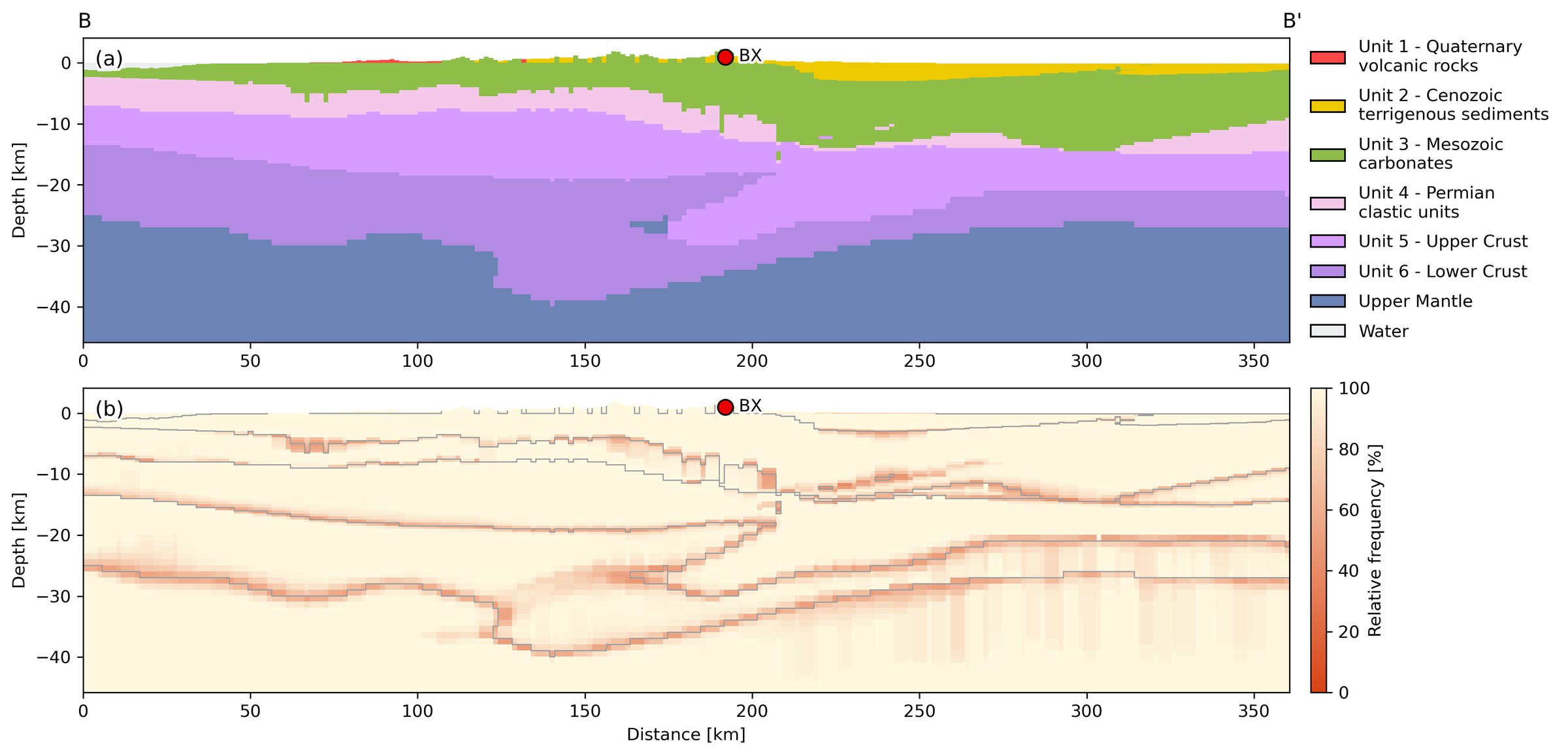
Virtual cross-section BB' through Borexino (BX): (a) GUESS unit geometry; (b) voxel-wise relative frequency of the modal label across the 1,000 refinement inversions.
Download
The GUESS model described in this page is freely available for download. If you use it in your work, please cite:
The model, provided as a resampling on a 1 km × 1 km × 0.1 km grid, can be downloaded at this link: